March 7th - 13th 2013
Ending the week on a Wednesday afternoon is always a good feeling, but this time was even better as Owen and I were headed to the airport, destined for Nelson and then onto St Arnaud for four days tramping in Nelson Lakes National Park with Dad and Jo.
Starting our tramp straight from the motel car park was a novelty and a welcome change – no stiff legs from an early morning drive! With four days of fine weather ahead of us the plan was to traverse the St Arnaud range as far as we liked before dropping into the Travers River in time to make our 3pm water taxi on Sunday.
After leaving the motel at 8.30am we were soon making our way up the St Arnaud track to bushline. The weather wasn’t looking as good as what the forecast promised – low thick cloud surrounded us, but we remained positive that it would break up soon. An initial gradual climb led to where we turned off from the loop track and continued along a steep zigzag track to bushline. We were lucky enough to spot some Kaka along the way making a real fuss as we walked past. Much to our delight, the climb seemed to pass in no time and within 2 hours from the start we broke out above bushline.
 |
| Scroggin stop at bushline |
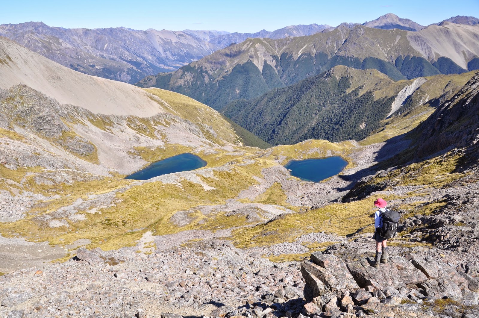
After a quick munch on my deluxe scroggin (dried strawberries and dark chocolate!) we were back into it and another 30min grind delivered us to the ridge. A sharp wind greeted us so we hurried along the pleasant ridge – a nice mix of tussock and rock and nothing too strenuous. As the first tarns came into sight we were pleased to see there was plenty of water in the big ones – being the end of a very dry summer we were slightly apprehensive about how much water we might find – no need to carry too much now!
 |
| The first tarns coming into view |
We dropped down to the first large tarn on the left to escape the wind and find a lunch spot. Following lunch, we had an easy sidle to re-join the ridge just past point 1796 and much to our delight the cloud cleared and the sun was soon beaming down on us! The ridge from this point had too much loose rock to follow so we dropped down to the basins on the right and followed easy tussocks up to the tarn just below point 1813.
 |
| The basin we followed just below the main ridge |
A short climb followed before we popped across the ridge between points 1820 and 1813 – and what a surprise we were greeted with – a bulldozed track around the next basin! We knew we would come across Rainbow ski field but hadn't really thought what this would look like in mid-summer. Quite a cool site to see plus it provided very quick and easy travel all the way to point 1696.
 |
| Rainbow ski field |
 |
| Looking down on the lower slopes of Rainbow ski field |
A pleasant slog up Mt McRae rewarded us with beautiful 360 degrees, from the Arthur Range, to Raglan Ranges and deeper into Nelson Lakes National Park. The ridge beyond Mt McRae was a bit of a scramble in places and required a bit of concentration on tiring legs but was well worth the effort once Arnst basin came into view – so many beautiful tarns perched beneath the steep craggy peaks beyond. We dropped down a short scree and were soon setting up a camp next to the largest tarn. Arriving at 6.15pm and after almost 10 hours of walking we got onto a quick dinner and all crashed into bed not long after dark.
 |
| Campsite at the head of the Arnst basin - the ridge for the next day behind |
 |
| Looking back on our campsite |
A relaxed morning saw us set off from camp at 9.45am, heading towards the slightly daunting ridge ahead. Going was initially easy with a mixture of sidling and climbing over some tussock shelfs but once we were directly below the step stuff we had to a make a decision. We could either drop down into the head of the Arnst River and head back up tussock basins to join the ridge again around point 1907 or we could traverse scree and rock under the really steep sections and join the ridge beyond point 1840 in the hope that the rest of the ridge was ok. We took option 2 – mainly due to laziness and not wanting to lose any more height! It was a fun scramble to get to the ridge – the sort of travel I love – difficult enough that you have to think about where you are going but not hard enough to be scary. We reached this point in 1 hour 15minutes from camp so were pretty pleased with progress and even more pleased to be greeted with tussock tops.
 |
| Happy to reach the main ridge before we realise what is to come! |
 |
| A gnarly bit of ridge we avoided |
Unfortunately our luck was about to run out – the ridge started out very easy going but within a few hundred meters the tussocks petered out and we were back to a rock scramble. Following a few gnarly sections and being bluffed out on multiple occasions we decided to drop down towards the Arnst River. Turns out option one would have probably been the best option after all! We only dropped down low enough to sidle under the steep bluffs and joined up with the ridge again just before point 1907. There were some good tussocks ribs and easy scree so as far as unplanned sidles go it wasn’t too bad. At 1.40pm we settled down for a well-deserved lunch on point 1880 and figured out that approximately 1km of ridge took us 2.5 hours!
Following lunch, the ridge was nice and easy – a few small rock scrambles and sidles but nothing very technical. We were treated to a great paragliding show with several playing around right above us! At around mid-afternoon the next two big tarns came into view (sitting below point 1803) and we decided this would suit us quite nicely to camp for the night.
 |
| Perfect spot for camp with the ridge to The Camel behind |
We had toyed with the idea of going along to the tarn below The Camel but it looked a lot smaller on the map so there was the risk of it not having any water – plus these tarns looked far too nice to pass by! It took us about 45mins to drop down to them, ending the day at a total of 6.5 hours since we began. Although a bit rocky and hard to find many flat spots we were still able to set up a beautiful camp beside the top tarn. It was the perfect swimming spot with some great rocks to jump off – providing much amusement for the rest of the afternoon.
Day 3 started with a traverse out of our camp spot back to join the main ridgeline. This was very easy going across tussocks and a few rocky sections. We joined up with the ridge after 45 minutes, just before point 1722. The ridge from here was really great, providing fast pleasant travel.
 |
| The ridge to The Camel |
Once the tarn below The Camel came into view we were glad of our chosen campsite – there was water in it, but not much and it just looked a bit stagnant. The climb up to The Camel was a fun scramble, we ended up coming off to the left of the main ridge and scrambled up some boulders/large scree before one last push up a steep bit of smaller scree and alpine plants to the top.
 |
| Scramble to The Camel |
 |
| Views down the Travers valley just below The Camel |
We arrived at the top at 11.45am and had wonderful views to all directions. Keen to enjoy it for as long as possible we decided to have a long lunch here. With the sun beating down it was lovely and warm and I could have happily dozed off for a few hours! There was even the perfect rock seat with my name on it.
 |
| Dad and I on The Camel |
Reluctantly leaving The Camel, we sidled under the main ridge on a very barren, rocky landscape to join the ridge up again at a saddle just past point 1785. Here we found a nice small tarn that wasn’t marked on the map to get some water from. The area surrounding the tarn was especially green and lush, providing a beautiful contrast to the landscape we had just come across.
 |
| Looking back to The Camel |
The ridge from here on looked quite gnarly – similar to the nasty section from the day before so if you were wanting to go on to Cotterell Peak, the best route would probably be to sidle through the basins on the NW side of the ridge. We however ended our St Arnaud range traverse here and decided to drop down to Travers River. There was a very small tarn on the map just before ridgeline and with luck we hoped there would be enough water for us to camp there. An easy hour descent brought us to the tarn at 3pm. There was just enough water – very stagnant water but it was such a beautiful setting with the backdrop of Mt Cupola and Mt Hopeless looming over us that we decided this would be home for the night.
 |
| Last campsite with Mt Cupola and Mt Hopeless behind |
The only downfall of the campsite was an unusual number of wasps hanging around – they don’t usually venture above bushline but we thought maybe the lack of water this late in the summer had brought them higher. After setting up they seemed to leave us alone and we had a very pleasant evening taking in the sites and reflecting on a great couple days along what is probably one of my favourite ridgelines.
We got off to a reasonably early start on our final day (8am) to try and avoid the wasps in the bush. This trick seemed to work well as apart from a couple of backtracks to avoid potential nests, we saw a very small number of them. The bush was open and easy going and we were down in the valley in just over an hour. From here we crossed the river and joined up with the main track leading us to the head of Lake Rotoiti. With our only deadline being the 3pm water taxi we took a very leisurely walk down the valley – stopping lots to take in the view and make the most of being in such an epic location before heading back to reality.
 |
| Back in the valley with the St Arnaud Range above |
We arrived at the head of the lake with an hour to spare so took the opportunity for another refreshing dip and yet another lunch feed. Our nerves were tested a little as the water taxi didn’t show for a while before finally arriving at 3.30pm – turns out they had forgotten our booking! Luckily Les and Christine were waiting for us at St Arnaud and had asked when they were coming to pick us up. Since Owen and I had an evening flight to catch back to Auckland we were very relieved that we weren’t left stranded at the head of the lake – or maybe not, another day off work and in the mountains wouldn’t have been too bad! Back in St Arnaud, Les and Christine provided a great feast for us to finish the trip on. Some quick goodbyes and we were on our way to the airport in Nelson while Dad and Jo headed in the other direction back to Chch. A fabulous trip that whetted my appetite for some more Nelson Lakes exploring – 4 days provided plenty of time to pour over maps and come up with ideas for some more adventures!


Thanks for sharing. Great photos and description.
ReplyDeleteThanks for your excellent description of St Arnaud range. Its whet our appetite for checking it out beyond our usual day walking up there.
ReplyDelete